|
|
|
|

|
|
12/22/2015
|
Happy Holidays!
Datecs GIS Center wishes you Merry Christmas and Happy New Year!
|

|
|
|
|
11/18/2015
|
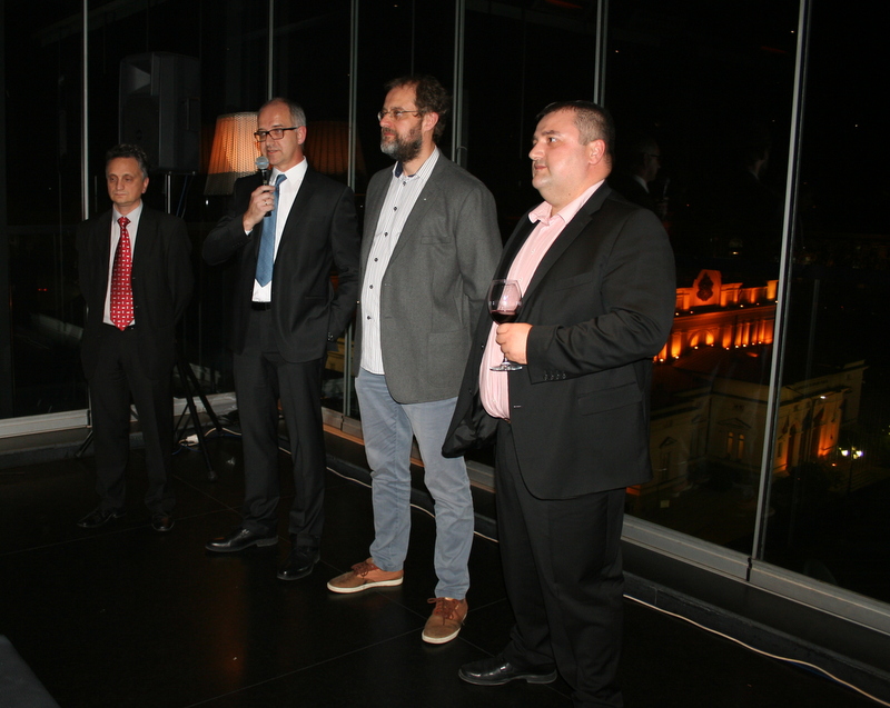
GIS ALLIANCE Bulgaria Celebrated World GIS Day
On 18-th of November, GIS ALLIANCE Bulgaria, comprising of the leading Bulgarian GIS companies TechnoLogica, Mapex, Datex, Datamap, Bitmap and GAP Consult, celebrated the World GIS Day with a seminar and a festive coctail party. The event was held in the Sense modern design hotel where the guests had the opportunity to enjoy the panoramic Sofia night view of the roothtop bar.
Presentations under the motto "The diversity of GIS" were watched by over 120 representatives of the GIS community. Many successful projects were presented which were brought to life through different GIS platforms: TOBEL, Luciad, TIMS, MapInfo, BGmaps and , also, open source systems. Among the organizations which shared their experience were the Military Geographic Service of the Ministry of Defence, Sustainable Energy Development Agency (SEDA), Pirin National Park, Interactive Bulgaria National Association, Asarel-Investment JSC and more.
The academic community represented by the University of Mining and Geology "St. Ivan Rilski", the University of Architecture, Civil Engineering and Geodesy (UACEG) and the Sofia University "St. Kliment Ohridski " also spoke about their achievements in the field of GIS: the use of unmanned aerial vehicles (UAV) in providing spatial information and GIS as an informal educational approach.
The various presentations and demonstrations provided an opportunity for the participants to see and compare different GIS solutions applicable in both the private sector and in government organizations. Members of the GIS ALLIANCE Bulgaria believe that it's useful and important for the users of GIS to know their diversity in order to be able to choose the most suitable platform.
During the cocktail the first anniversary of The GIS ALLIANCE Bulgaria was celebrated with an acoustic surprise and a cake. The companies of TechnoLogica, Mapex, Datex, Datamap, Bitmap and GAP Consult proved that they could overcome the natural rivalry and could complement each other in terms of their competencies and services.
|
|
|
|
|
09/29/2015
|
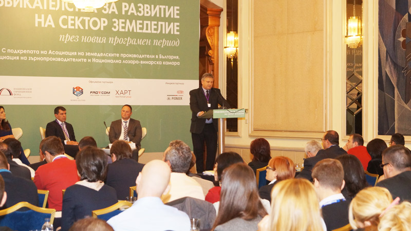
Datecs GIS Center participated in the forum "Challenges for the development of the agriculture sector in the new programming period"
Datecs GIS Center participated in the forum "Challenges for the development of the agriculture sector in the new programming period", organized by ICT Media and "Capital" in the Balkan Hotel in Sofia on 29 September 2015. The conference presented the opportunities for EU funding in the new programming period, the main priorities, the preparedness of the Bulgarian administration and business to absorb EU funds as well as the new technologies and examples of implementation of ICT in the sector.
Stanislav Derekyovski "Datecs GIS Center Commercial Director" and Ognyan Stoyanov "WEB design and Programming Expert" presented the capabilities of the Integrated Administration and Control System (IACS) of the State Fund "Agriculture", which ensures the distribution and payments of EU funds.
A number of options for technical updates related to the regulatory requirements and the growing needs of the system users were exposed.
|
|
|
|
|
11/24/2014
|
International Conference 'The Future of the Lower Danube' - Svishtov
The General Manager Kiril Vachov and the Commercial Director Stanislav Derekyovski represented Datecs GIS Center at a large scale forum event - the International Conference “The Future of the Lower Danube: Promotion of Regional Economy - Intelligent Cities - New Infrastructure” held in the town of Svishtov at the Tsenov Academy of Economics .
The large-scale forum was organized by the Federation of Scientific Unions, the Union of Economists in Bulgaria (UEB), the Tsenov Academy of Economics, the Government of Baden Vurtenberg – Germany, the "Konrad Adenauer" Foundation, the Association of the Danube Municipalities in Bulgaria - "Danube" – and the National Cluster for Intelligent Transport and Energy Systems (NCITES) - Bulgaria. The conference was attended by guests from Germany, the Netherlands, Norway, Switzerland, Georgia; there were representatives from the Ministry of the Economy and the Ministry of Regional Development and Public Works (MRDRW), governors and mayors from the Danube regions, representatives of NGOs (non-governmental organisations) and academic professors. There was simultaneous interpretation in English, German and Bulgarian.
Mr. Derekyovski presented GIS modeling and analysis of flood crisis scenarios with modern GIS techniques. At the closing session, the participants in the international conference discussed and adopted the ”Charter for the development of the Lower Danube". In this document a conviction was expressed that regional integration along the Danube is a prerequisite for the implementation of a uniform policy for economic growth.
|

|
|
|
|
11/20/2014
|
GIS Alliance Bulgaria celebrated the World GIS Day
On November 19, the leading Bulgarian GIS companies Mapex, TechnoLogica, Datex, GAP Consult, Datamap and Bitmap celebrated together the World GIS Day in Bulgaria.
The conference held for the occasion gathered more than 100 representatives of the GIS community. The event program included presentations by both the organizations that have implemented GIS projects and the companies offering solutions in this area. Representatives of the Geodesy, Cartography and Cadastre Agency, GIS-Sofia and Military Geographic Service – Ministry of Defense shared views on the benefits and opportunities that the implemented GIS solutions provide.
The members of the GIS Alliance Bulgaria acknowledged that they have left behind competition with each other and share the common belief that in a mature market rivalry on products should be replaced by complementation and cooperation in terms of competencies and services. GIS Alliance Bulgaria would like to allow customers to make comparisons, share experiences and best practices in order to choose the most appropriate solution for their needs.
"We want to develop the market, to invest in the promotion of GIS technology, to increase the interest of the young people in it, and to prove that Bulgaria can implement successful working projects in different areas , with different platforms", said Ognyan Trayanov, CEO of TechnoLogica at the opening of the event.
Deyan Baltadzhiev from Mapex presented the project for Establishment of National Geographical Information System for potential production and consumption of RES, implemented for Sustainable Energy Development Agency (SEDA) and also the GIS system developed for the green areas of Haskovo.
Datecs GIS Center presented the full range of services offered, with emphasis on Bulgaria-Info data and the popular internet platform Bgmaps.
Svetozar Zahariev from TechnoLogica presented the largest GIS project in Bulgaria for the last 3 years – GIS for the management of port infrastructure for the Bulgarian Ports Infrastructure Company.
The diversity of themes was supplemented by information on the new features of the MapInfo GIS software and the Trimble solutions for GIS and a presentation about the Climate Risk Information System developed for the Republic of Maldives and implemented by GAP Consult.
GIS Alliance Bulgaria demonstrated to the participants that GIS technology is not meant just for a closed group of professional users. It can provide information about a that complements the information systems in many areas: central and regional administrative management, guaranteeing citizens’ security, protection of the public order and emergency management, management of engineering and transport infrastructure and assets.
|

|
|
|
Page 1 from 12: 1 2 3 4 5 6 7 8 9 10 11 12 Next >>
|
|
|