|
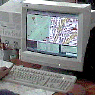
Heads-up digitizing
In the beginning of 1993 we have selected the
heads-up digitizing - a modern way to work. Since then all our completed
projects are successful - which proves that we have made the right choice. The
heads-up digitizing allows most effective resources management and gives maximum
productivity, accuracy in management of large maps and plans.
top
|
|
Digital cartography and high-quality maps for printing
The development of high-quality digital maps for printing, based on geographical
data, is still a difficult process. It requires professional approach, perfect
planning, rich experience of the involved people and a lot of handwork. MapInfo,
FreeHand and Photoshop are the programs we use, as well as software applications
developed by us to automate the different processes. We believe that during the
last 10 years we have gain the right experience to provide the best-quality
services for our Clients.
top
|
|
GIS and Mapping applications and Internet solutions development
The software department of GIS Center has lots of interesting proposals for you:
- GIS and Mapping application and solutions
- GPS tracking applications and solutions
- Internet GIS and Mapping development
- Digital cartography utilities and applications development
- Development of data conversion and transformation tools
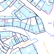
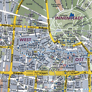
Two of our leading projects for Germany are
|
|
GIS databases, integration and complete solutions
The time when the GIS systems were complicated and
custom solutions, served by specialists, has gone. Today the GIS systems are
part of the information system of the company or the organization. They require
specific knowledge and IT background. We are proud to have high-specialists in
different domains - GIS, mapping and geodesy, IT and software development,
education and management. This makes us believe we can offer complete solutions
to our clients.
top
|
|
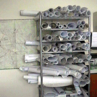
Map scanning size up to A0+
The number of the places where you can scan maps or other images or
documents increases constantly. But when the quality is a must - we
believe it is better for you to make a careful choice and to select
a professional company with experience to do it. We do scan maps for
years, in all formats, size up to A0+ and 15mm thickness. We deliver
quality products and we know how to keep your deadlines.
top
|
|
Raster manipulation and registration
The raster manipulation and registration are part of the main
activities in the mapping. But it must be done professionally to be
with good quality. We do preliminary evaluation on the baseline
materials for each project and we select the best fitting formats
and solutions for the rasters and their registration.
top
|
|
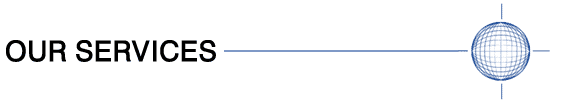
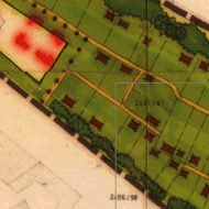
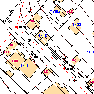
Cadastral and utility maps digitalization
Each database requires to be complete and precise. The same is with
the GIS databases. But this requirement is a must for cadastral and
utility maps. Our rich experience includes many completed projects
for France and Bulgaria - where all the requirements for completeness
and topology are met.
top
|
|
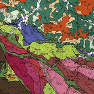
Geological maps vectorization and topology building
Specific knowledge not only in GIS, but also in geology and geography
are needed for the work on the vectorization of geological maps. We are
happy to have specialists with University education working for us,
providing best quality for our Clients.
top
|

|
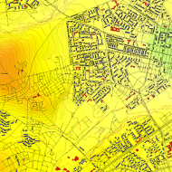
Demographic data entry and thematic mapping
The GIS has started as demographic data entry and thematic mapping to
reach their place in the today’s business. More and more the decisions
taken by the marketing and advertising specialist and the businessman
are based on geographical and thematic analyses, done with the support
of GIS.
We have the opportunity to be among the first in Bulgaria with one of
the leading companies world-wide as client - The Coca-Cola Corporation.
Together we have done lot of different and interesting projects,
applied later on to the offices of Coca-Cola in the whole Balkans’
region. This we do with pleasure, because the level of creativity such
work requires is high - something we try to apply whenever possible
in our everyday work.
top
|
|
3D data entry and terrain modeling
The question is: fully-automated or semi-automated process to use in
the 3D data entry? The fact is that the cases when you can use
fully-automated vectorization are not frequent. There is always
necessity the data to be “cleaned-up”. Again - the fruitful choice
is professional operator, working with the best software and fast
hardware. GIS Center offers exactly this for you.
top
|

|
Scanning, OCR and multilingual data entry
Even if the scanning and the OCR processes look easy and routine for
you, when the amount of work is big and the quality is a must it
could become a problem. Again - we offer professional solutions
with multilingual support - English, German, French, with semi- or
fully-automated process of data recognition and processing. Our reach
experience with the ABBYY FineReader brings for you high-quality and
very good delivery time.
top
|